Support for a Ground Breaking Project
EDS were pleased to support Glanville Geospatial team with a complex integrated survey of Bristol Harbour.
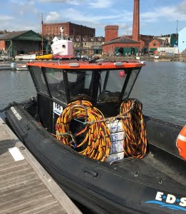
The deployment of sonar equipment from our workboat assisted with some of the data collection for this ground breaking project for Mott MacDonald https://www.mottmac.com/ and Bristol City Council https://www.bristol.gov.uk/
EDS also provided a workboat and safety team to assist with drone surveys (by Terradrone – https://terra-drone.eu/en/) along the length of the River Avon New Cut as part of this project.
This task was extremely challenging to undertake because of difficult access environments. Everyone was involved in the meticulous planning around tidal and weather constraints, with the only useable access via an old slipway. One of our foldable RIB vessels was used as it was perfectly suited to the conditions. Follow this link for more info on the project https://www.glanvillegeospatial.co.uk/2020/06/25/complex-integrated-survey-of-bristol-harbour/?utm_source=Glanville+Geospatial+Services+newsletter&utm_campaign=ed2288ebb0-ENEWS_July_2020&utm_medium=email&utm_term=0_b9114622e4-ed2288ebb0-12622775


